Spotting from the Edge of Danger Zone
Mountain “Wildgärst” during Axalp Swiss Air Force demonstration
The Axalp air power demonstration is one of the most famous aviation events in the world. Every year in October, the Swiss Air Force will displays their skills at Axalp–Ebenfluh, a air force shooting range. At this airshow the fighterjets practice target shooting with ammunition and also displays with paras, helicopter, turboprop planes and the famous Swiss aerobatic team Patrouille Suisse. The Axalp airshow is legendary and unique in the world, a highlight for everyone set against a stunning alpine landscape. The demonstration is an experience that you will never forget.
But there is a catch. The shooting range is located at an altitude of 7365 feet (2242m) in the middle of the Swiss Alps. This is already alpine territory, the visitor requires a good level of fitness and hiking experience. Some visitors reach their limits on this hike to the three main public viewing points. It's doable but you have to stay focused.
You can find much information about this special airshow on the internet. I won’t explain it again here. Feel free to contact me if you need additional information.
Axalp 2025 site
Fyler 2023 with informations (German only)
For a first-time visitor, your best option is to experience the official public area. It’s more than enough for most people, and you'll stay close to the action.
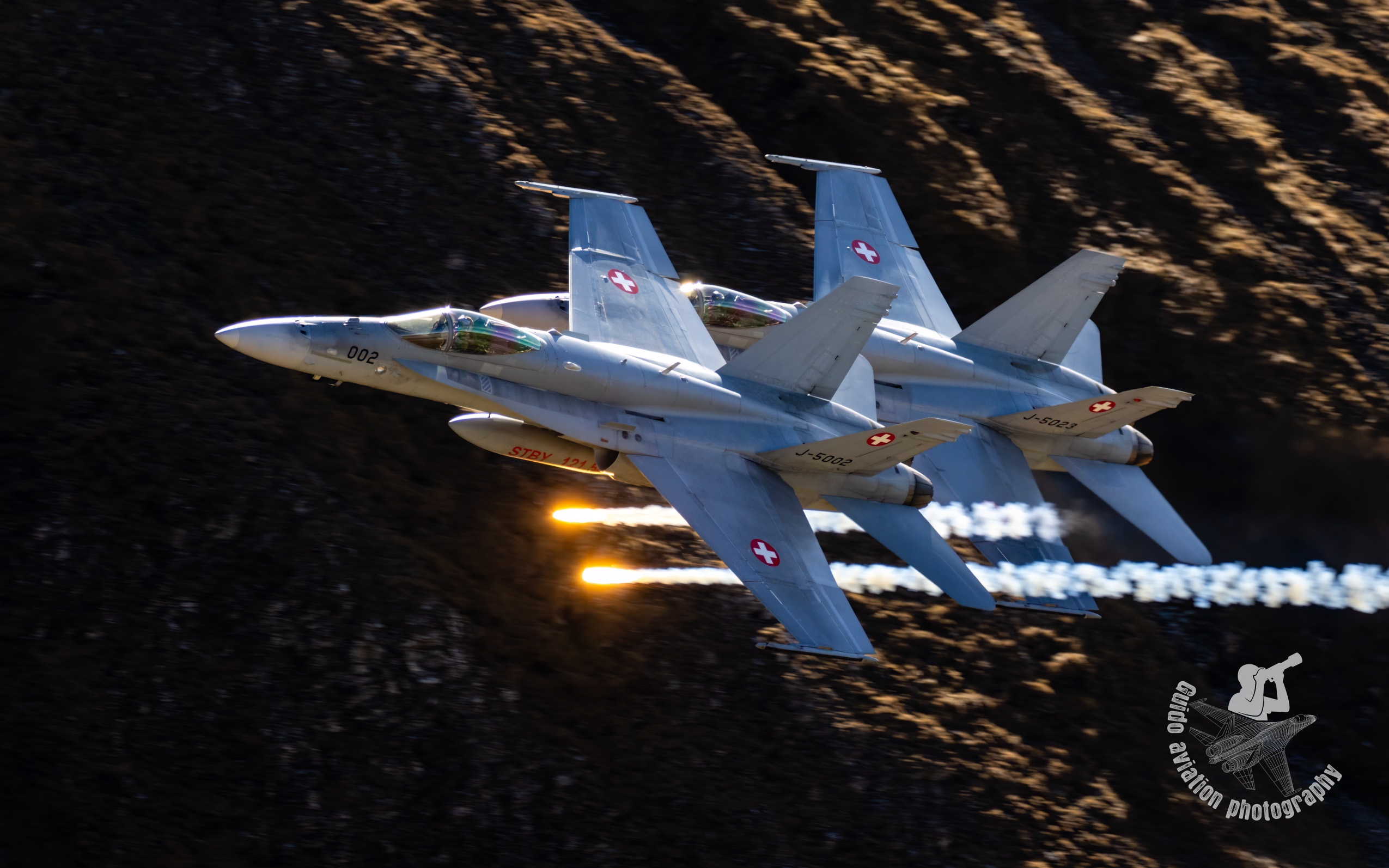
If you have been at Axalp at least once, you have probably see these few silhouettes on the high mountains on the other side of the valley - being way above the aircraft, with the sun behind their backs, in absolutely perfect photo spots.
Have you ever wanted to get there?
Some insiders call it “the other side” or refer to the mountain “Wildgärst”.
2'891 Metres above sea level (9485 ft)

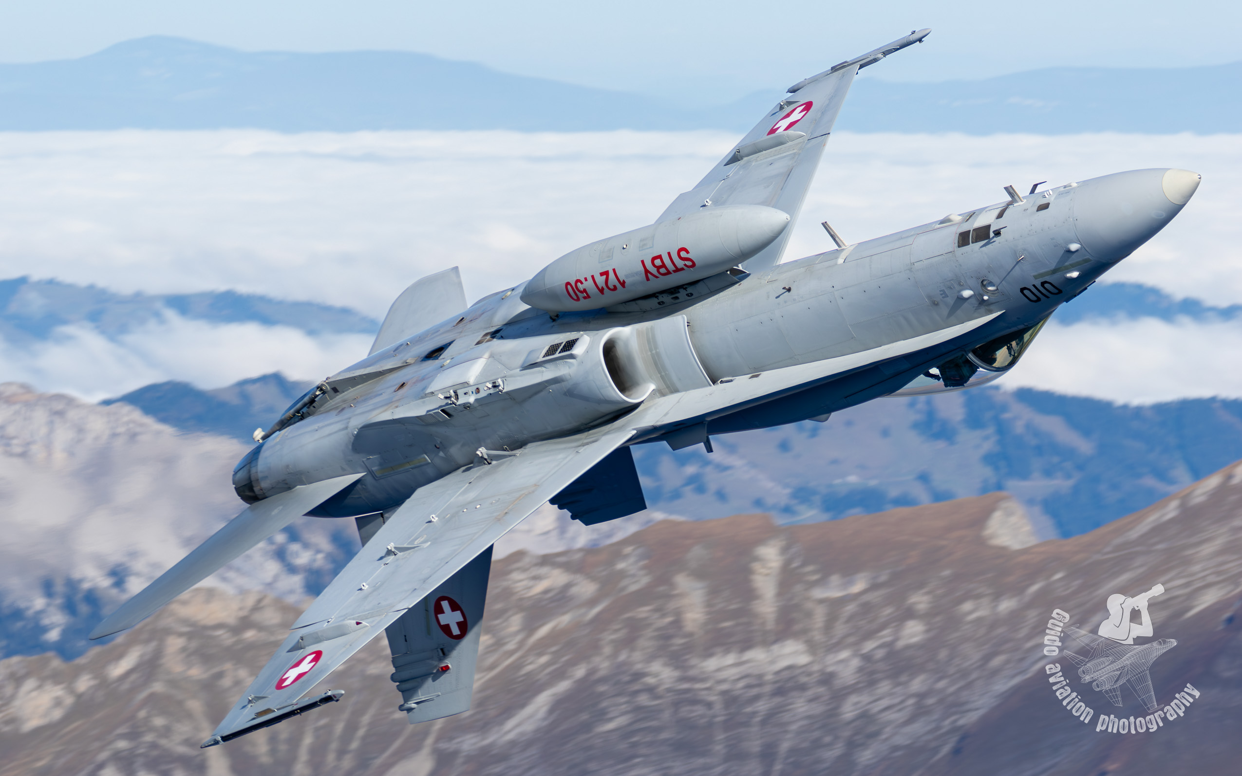
I prefer that spot for unique shots of inverted Hornets in front of the mountains. But I'd rather leave a picture than an impression. Keep in mind that the Hornet flies over the mountain at a distance of approximately 130-160 feet (40-50m).
I'll try to give a few tips for those who would like to experience it: However, there are some requirements that you have to meet to ensure your safety and that the strenuous hike ends safely at home. It's not for the faint-hearted; it requires mountaineering skills.
Some control question if you are the right person for this hike:

Start of the route can be from different start points:
Green: Is the normal way to the the official public area. With or without the chairlift.
Cyan: Schwarzwaldalp: 4 houres hike up with about 4800 ft altitude difference (1450 meters), 7.4 km
Yellow: Grosse Scheidegg: 3.5 houres hike up with about 3280 ft altitude difference (1000 meters), 6.5 km
Red: Axalp Village: 5.5 houres hike up with about 5250 ft altitude difference (1600 meters), 10.2 km
Blue: First: 3.5 houres hike up with about 2950 ft altitude difference (900 meters), 8.4 km
There are other options, but they are not for everyone and are even more demanding.
I admit I haven't tested all of them myself or only partially. I would also say that I am fit and therefore travel faster than the times given by normal hikers.
I preferred the Schwarzwaldalp route. Easy to reach and gives me the most flexibility.
Schwarzwaldalp you can reach by car or public bus. Parking one day is 8 CHF. Don’t forget it or you have a penalty charge notice.
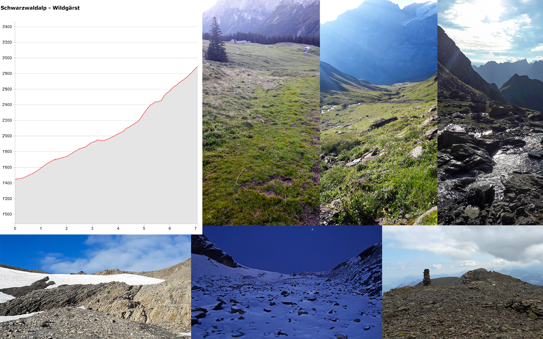
The first, easiest part leads through forests and grasslands. The middle section becomes rockier, steeper, and includes some stream crossings. Then it becomes even steeper and rockier, possibly with snowfields.
And if you think it will end soon, it's challenging as the air gets thinner and thinner. But it's only a small, stony section to the finish. When you reach the top completely exhausted, you realize you're only halfway and soon have to descend.
That's why I highly recommend trying this hike in the summer with the best weather conditions before considering it in October.
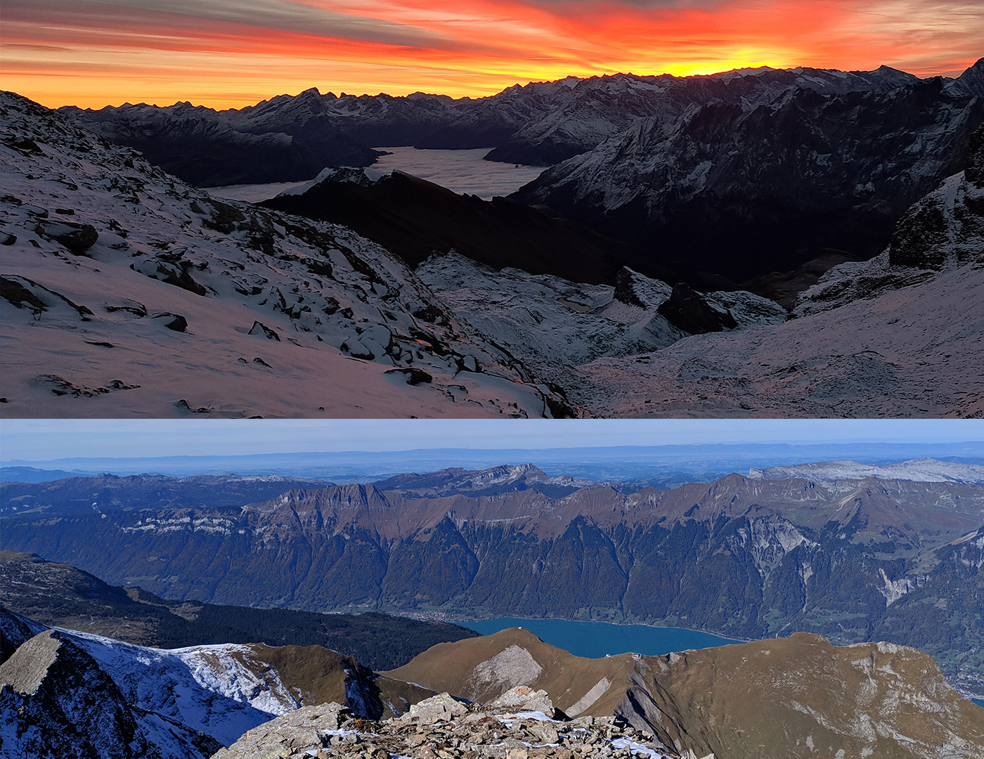
At the top, you'll have a fantastic panoramic view.
But remember, you'll be at almost 10,000 ft, and temperatures are around 0 degrees. The weather can change abruptly. Proper winter clothing is essential.
Photography at Wildgärst
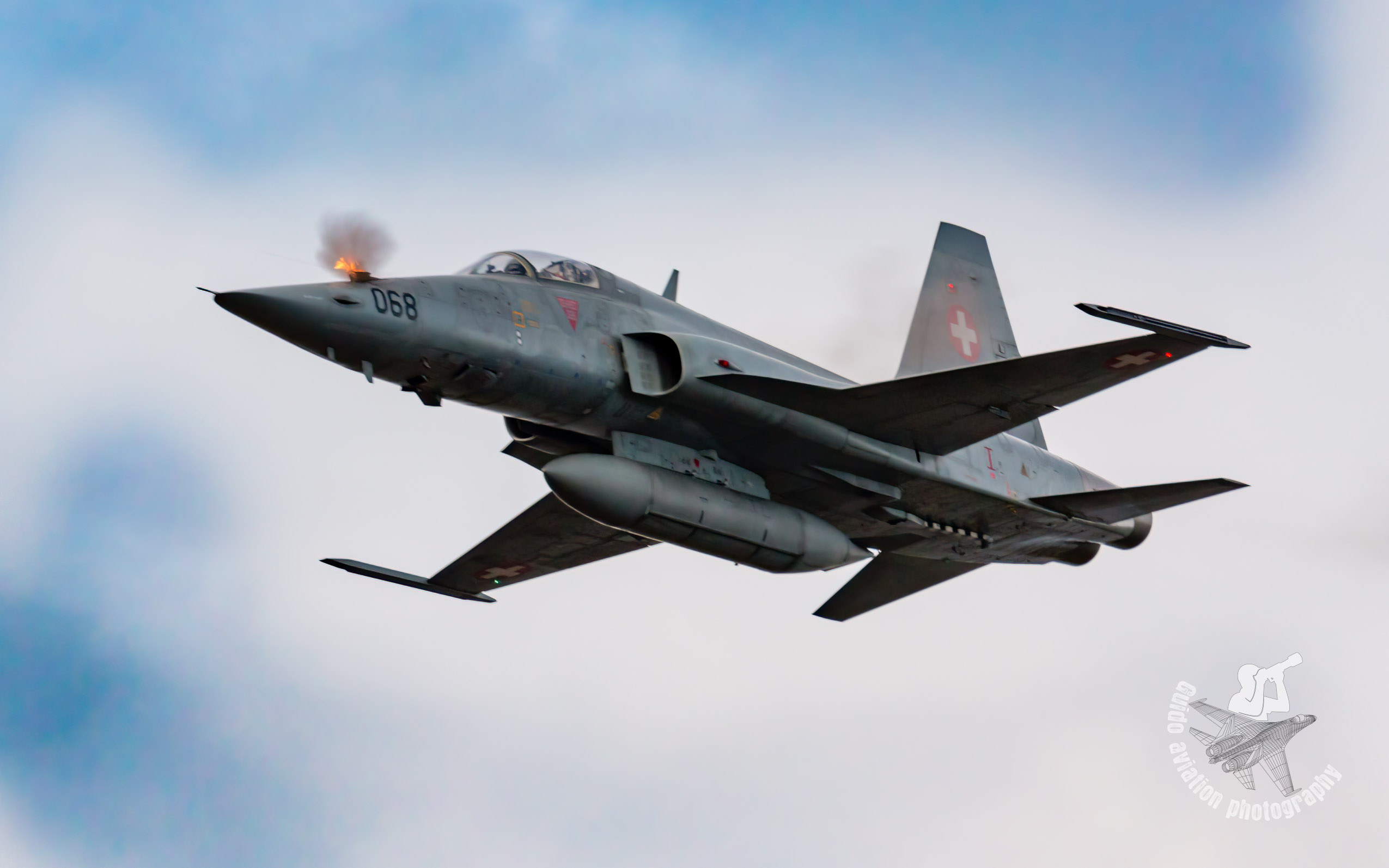
You're too far away for the actual show, but you'll have a clear view. Therefore, you'll need to pack a lens with a large focal length (500mm+).
However, you ascend for the opportunity to capture close-up shots of Hornets and the Pilatus PC-21. Stay prepared with warm fingers as jets approach rapidly. In just a few seconds, you have the chance to capture a good exclusive shot.
It's a unique experience when they fly so close and fast. You'll also need considerable zooming capability to capture them in full detail.
Remember, depending on the attack pattern or weather conditions, it's not guaranteed that they'll fly over every year.

summarized a few points
good preparation: route , time requirements and reserves
Experience: only for experienced hikers
Fitness: A very high fitness level is required, and you need to be in good physical shape
Safety: Don't go alone; preferably hike with a similarly fit friend
always stay outside the danger zone. You can view the exact boundaries here.
Weather: only go there in perfect weather conditions
Feedback from all the people who have been there indicates it’s still very hard, and you should plan 4-6 hours for the climb up and 2-4 hours for the descent. The route is steep, slippery, and will probably be covered with snow.
I hope I've provided some insights, and I'm also open if anyone wants to find out more.
Maybe we'll meet at an airshow sometime. Axalp or who knows, maybe on the top of Wildgärst.
Cheers Guido